
Due to the forest on our property, calculating sun angles is critical data for selecting which trees would need to be cut down for solar access and which trees beyond that southerly triangle can live on into the future. I researched how to create a solar path chart for wherever you are located in the US. This provides an informative graphical chart that shows the sun’s angle above the horizon – and its east to west solar azimuth – throughout every hour of the day over a 6 month period from winter solstice (least/lowest sun) to summer solstice (most/highest sun).
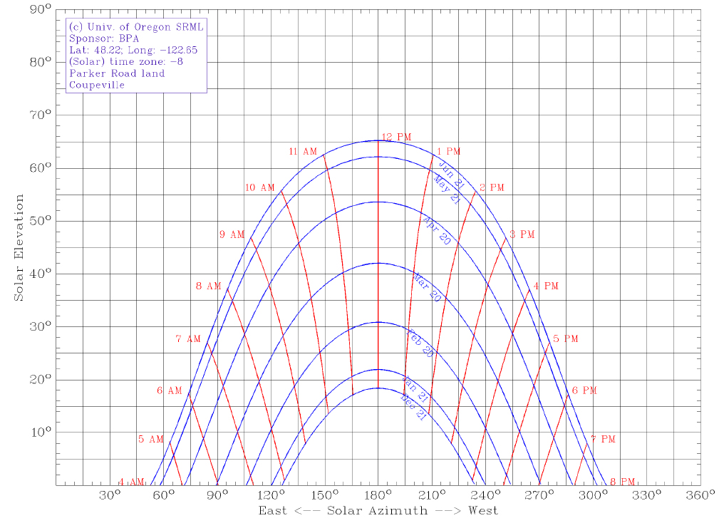
Solar path chart
First step easy option: Have your zip code
- Just know the zip code of your area of interest.
- Skip below to “Second step: Input your location data into solar chart program”.
Or First step more exact option: Determine your lat/long
To determine your location’s latitude and longitude, I recommend going to TopoZone (www.topozone.com). Once there, do the following steps:
- Click “View Maps” in upper left.
- Click on your state.
- Click on your county.
- Click on the type of area you’d like to locate. Click “Populated Places” if you want to hone in on a particular town.
- Scroll the list and click on your town name.
- A map will appear. to find your exact location, you can use different controls: use left/right/up/down arrows around the map, click Small/Medium/Large map size on the left navigation column to get a wider view, and/or change the “zoom” level by selecting a different scale under “View Scale” on the left navigation column.
- When you have your general area in the map view, then click on the exact location you want to get lat/long for. The map will re-center itself so that where you clicked is in the center.
- On the left navigation bar, under “Coordinate Format” click “DD.DDD”.
- Near the top of the page (a few lines above the map) you will see the latitude and longitude coordinates for your location.
Second step: Input your location data into solar chart program
- Go to the University of Oregon’s Solar Radiation Monitoring Laboratory at solardat.uoregon.edu/SunChartProgram.html.
- Scroll to Step 1 on their web page.
- If using your zip code: Click the little button by “Look up location with” and type in your zip code.
- If instead using your lat/long: Copy your latitude number into the first box. Copy your longitude number into the second box (note that western hemisphere longitudes such as the US are represented with a negative number).
- Go to Step 2 on the page, and select your time zone.
- You can skip all the rest of the steps on the web page unless you want to fiddle with it. Note that in Step 5 you can add a title or comments to the chart (such as your name, address, location description, or such).
- Scroll to the bottom of the page and click the “Create chart” button.
- On the next page that appears, click the underlined “here” text to see the pdf version of your sun chart.
- You can then either save this chart as a pdf file or else print it out directly.
And there you have it, your own solar path chart!
STAY INFORMED WITH OUR NEWSLETTER
SEARCH
CATEGORIES
ARCHIVES